DAY 2 Saturday Aug 31, 2019:

On the previous day, we had not found a
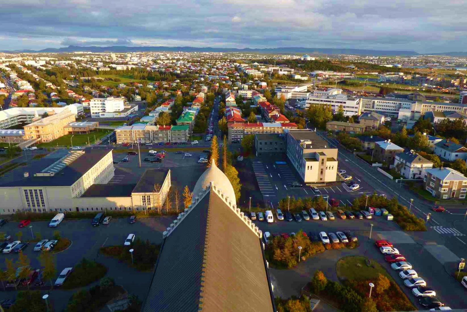
parking space near HARPA in Reykjavik, I wanted some pics there, so
we retraced and went back to HARPA before staring on our main drive
of the day …. the Golden circle.
[this backtracking will become a theme
of our trip.... on most days....I'm a tad ashmed to say!]
HARPA CONCERT HALL is the home of
the National Symphony Orchestra .

A statue of Danish cellist Erling Blöndal Bengtsson is in front.


The building had looked much better at sun set but anyway we took our pics and then started driving to the nation’s heart, Thingvellir National Park.

A statue of Danish cellist Erling Blöndal Bengtsson is in front.


The building had looked much better at sun set but anyway we took our pics and then started driving to the nation’s heart, Thingvellir National Park.
We took road no. 1 heading north out of
Reykjavík.
Thorufoss/ þórufos:
Our first stop was at thorufoss/
þórufos after a detour of 10 km on a decent road.. When we parked
and got out, we thought the falls we saw tumbling far away on the hill
was the attraction.


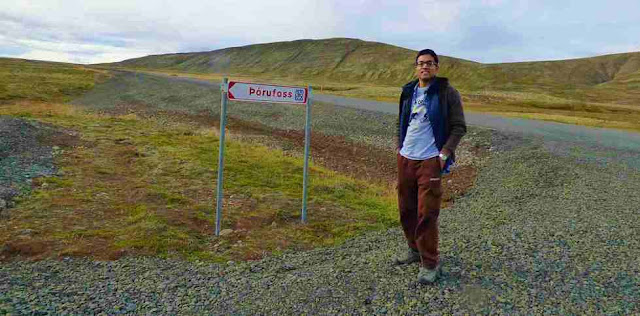 Then when we walked a little further we saw the river and falls to the right. Quite pretty.


Thingvellir/Þingvellir National Park:
We resumed the drive. After driving
through the town Mosfellsbær took the first exit to the right at
roundabout onto road no. 36 to Thingvellir.

Thingvellir National Park is a UNESCO heritage site, and the world’s oldest parliament was established here in 930
AD. [The first permanent settlers to Iceland came in the
800s and were largely vagabond clans who refused to bend a knee to
the new High King of Norway. In 930 AD, they decided that a
collective government could ease disputes, and each of the thirty
groups present sent someone to represent them. They deemed their
meeting place ‘the fields of parliament’, which translates to
Þingvellir.
In fact, since its establishment over a
millennium ago, it was only interrupted for one spell, from 1799 to
1844. After that, it was relocated to Reykjavík, but its function
remained the same.
This history makes the Icelandic
Alþingi (parliament) the oldest, still ongoing, representative
parliament in the world.
Þingvellir witnessed many of the major
changes that the nation went through as it developed. Here the
country converted to Christianity in 1000 AD, fearing the
violence threatened by the pious monarch of Norway, King Olaf I.
It was also the site of many witch-trials.
It was here Iceland declared
its independence from Denmark in 1944 after the Nazis
invaded it and the Allies took control of Iceland. The confirmation
of the nation's first ever president, Sveinn Björnsson, was
also held here]
The park is situated directly between
the North American and Eurasian tectonic plates, in the rift valley
that runs all the way through Iceland. When we enter the park from
Reykjavik, we drive towards a sheer cliff that is the corner the
North American continent. The Eurasian continent is several
kilometres away, on the far side of the park.
The area consists of long stretches of lava rock, and many volcanoes surround the park. There are still regular earthquakes in the area and the distance between the plates widens 2.5 centimetres (one inch) a year. The ravines opened by these quakes are filled with fresh water, which melts from the glacier Langjökull and travels underground through the porous lava rock towards the lake Þingvallavatn.
The area consists of long stretches of lava rock, and many volcanoes surround the park. There are still regular earthquakes in the area and the distance between the plates widens 2.5 centimetres (one inch) a year. The ravines opened by these quakes are filled with fresh water, which melts from the glacier Langjökull and travels underground through the porous lava rock towards the lake Þingvallavatn.

To see where the earth is tearing
apart, while staying fully dry, we can walk in the Almannagjá
gorge, against the North American tectonic plate.

This valley displays how the geological processes in the area work, and leads to a lovely waterfall, called Öxarárfoss.
We walked here just a little bit, then turned back, We felt the valley is famous for the geology, not necessarily for scenic value.
Browsed the gift shop and got back to our car.

This valley displays how the geological processes in the area work, and leads to a lovely waterfall, called Öxarárfoss.
We walked here just a little bit, then turned back, We felt the valley is famous for the geology, not necessarily for scenic value.
Browsed the gift shop and got back to our car.

'
We drove to the parking lot of Öxarárfoss. This led to a long hike with scrambling over loose rocks,
I decided not to go on; stood around at the viewing platform overlooking the gorge,

son went all the way to the falls and then came back; said the valley was not too worth the trouble. but the falls was good and he had seen a nearer parking lot.
We drove on to the next parking lot Parking #3 from where Öxarárfoss is a short walk. In fact this should be signed as Öxarárfoss parking, not the previous one.
The falls is actually man-made, dating back to the 9th century with the intent to provide water to locals.
Öxarárfoss:
We drove to the parking lot of Öxarárfoss. This led to a long hike with scrambling over loose rocks,
I decided not to go on; stood around at the viewing platform overlooking the gorge,

son went all the way to the falls and then came back; said the valley was not too worth the trouble. but the falls was good and he had seen a nearer parking lot.
We drove on to the next parking lot Parking #3 from where Öxarárfoss is a short walk. In fact this should be signed as Öxarárfoss parking, not the previous one.
The falls is actually man-made, dating back to the 9th century with the intent to provide water to locals.


Geysir Geothermal Area:
The second stop on the Golden Circle is the Geysir Geothermal Area, within the Haukadalur Valley.

It is approximately a fifty-minute drive from Þingvellir, on ROAD 365. We can see the unpredictable Geysir and dynamic Strokkur. The Great Geysir is the earliest documented geyser in European literature, and its name comes from the Old Norse verb geysa ‘to gush’ .
Geysir erupts rarely, but its neighbor, Strokkur, goes off every ten minutes or so, throwing water from 20 to 40 metres (66 to 132 ft) into the air.

[For a geyser to exist, it requires the
following circumstances:
An intense heat source: For geysers to
erupt, there needs to be magma close to the surface of the earth to
heat the rocks enough to boil water.
A water flow: There must be a source of
flowing underground water. In this case, the water is what has melted
from Langjökull glacier and runs through the porous lava rock into
the area.
A plumbing system: There must be an
underground reservoir for this water to gather, and a vent, lined
with silica so that the water cannot seep out of it, which rises from
the reservoir to the surface of the earth.]
The reason the original Geysir is
mostly inactive these days is because of the tectonic activity in the
area, as well as intrusive human intervention. Studies show that it
has existed for about 10,000 years and that it tends to erupt in
cycles; usually, a large earthquake will trigger it to start off,
then it will slowly peter out.
Strokkur frequently goes up to 20
meters high every 6-10 minutes. Geysir has been less active in the
recent years. But when it erupts, it can reach 70 meters high. The
area is filled with bubbling hot springs, steaming mud pods and
smoking fumaroles.


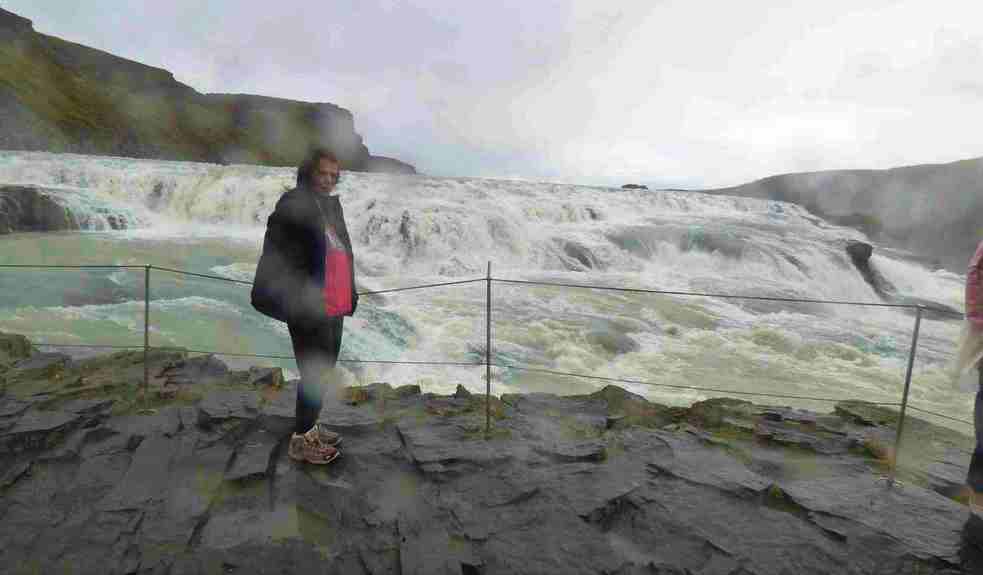
Gullfoss:
The third and final stop on the Golden Circle is one of the most spectacular waterfalls in Iceland, Gullfoss (Golden Waterfall), less than ten minutes down the road from Geysir.
Hvita river flows voluminously with a huge rumbling sound and rushes into the misty gorge. The energy is awe-inspiring. This powerful falls tumbles down two drops, from an overall height of 32 metres (105 ft).

At its heaviest flow during summer, an average of 140 cubic metres (4944 cubic feet) of water pours down it every second.


In the early 20th Century, foreign
investors saw a huge opportunity in damming Gullfoss and turning it
into a hydro-electric plant. The owner of the falls at the time,
Tómas Tómasson, had indirectly given outsiders the right to do what
they wanted with it. These plans, against his wishes, started to go
ahead; but were difficult to enforce with Tómas’ daughter around.
This iconic woman, called Sigríður,
refused to let the natural wonder she loved so much be destroyed. She
did everything she could to preserve it, from threatening to throw
herself into the falls, to walking the 200 kilometres of unpaved road
to Reykjavík and back again multiple times to rally a legal case in
Gullfoss’ defence.
Her actions drew national criticism of
the plans and delayed the process of damning. Eventually, the lawyer
she enlisted managed to work with the investors, who were lacking in
money to take action, to annul the contract. This lawyer, Sveinn
Björnsson, was later Iceland’s first president
Sigríður has been immortalised in a
stone memorial on top of the waterfall and is remembered as a hero
for her efforts to save it. As a poor, uneducated woman fighting a
capitalist, patriarchal society in the name of the beauty of nature,
she helped pave the way for both feminism and environmentalism to
prevail in Icelandic culture.
We browsed the gift shop, found the prices high. Thought will hold out buying till we reached less known attractions


We browsed the gift shop, found the prices high. Thought will hold out buying till we reached less known attractions


Faxafoss:
We decided to detour and cover a couple of other sights before reaching our accommodation. Saw some lovely Icelandic horses on the way.


We drove to Faxafoss. It is known as Vatnsleysufoss in Icelandic. This waterfall has a wide cascade and a quieter drop. Paid for the parking at the counter. The waterfall is 80 meters wide and seven meters high. It is a beautiful waterfall in a peaceful landscape.


Kerid Crater:
Next was Kerid Crater, 500 ISK per
person. The volcanic crater was formed about 6500 years ago and is completely
oval with a lake in its bottom. The rocks surrounding the crater are
fiery reds and oranges, with streaks of black and green running
through them; these colors contrast beautifully with the azure
waters.
 Saw it from the top and then went down the steps... LOVELY


Kerið is also renowned for its acoustics; concerts have been held in it on several occasions.


Kerið is also renowned for its acoustics; concerts have been held in it on several occasions.
It had started off as a drizzly day and
there had been intermittent drizzles, nothing to ruin the day though. We drove on; Lovely rainbows kept us company...as the sun set over the captivating landscape


We had Urridafoss also on the agenda but in the hurry to get to our accommodation before dark, we forgot.
We reached Hlidarbol farmhouse a little past Hvolsvollur. Well signposted...There is a sign on the road, we need to go further in to get to the right house.


 Room is adequate with big openable windows.

 Common areas are great... big kitchen, living room and spacious washrooms.


 Had some rice and soup and called it a day!


Report on day 3 continues here:


We had Urridafoss also on the agenda but in the hurry to get to our accommodation before dark, we forgot.
Hlidarbol farm guesthouse:
We reached Hlidarbol farmhouse a little past Hvolsvollur. Well signposted...There is a sign on the road, we need to go further in to get to the right house.

It's a lovely farmhouse with sheep
roaming around and a hammock strung on a tree. LOVED IT! Parking in front of the
house.
Checkin/out is all automatic with instructions on email. Our code didn't work but a fellow guest opened the door for us.
Checkin/out is all automatic with instructions on email. Our code didn't work but a fellow guest opened the door for us.