Day 5, Aug 29, 2017:
Icefields Parkway:
Icefields
Parkway is one of the world’s most spectacular mountain highways. It is the
North-south highway route between Lake Louise and Jasper, Fifty minutes west of Banff, two and a half hours west of Calgary,
With an average elevation of 1,550 metres (5,100 ft), it is the
highest road in Canada.
Distance: 230 km (143
miles); Time: One way: 5 hours.
However, we need to allocate plenty of
time to check it out and enjoy this amazing part of the Canadian
Rockies. There are tons of hikes, vistas, glaciers,wildlife, meadows and more to see. Well
over 100 glaciers are within sight of the highway between Jasper and
Lake Louise.
Herbert Lake:
We started off from Banff as the sun
was rising, 7.30 am. First pullout was at Herbert Lake set within a forest of lodgepole pine.

AWESOME! Beyond the lake, to the south, the peaks of the Bow Range form a dramatic backdrop. These are the high mountains surrounding Lake Louise, and the highest is ice-capped Mount Temple (3,544 m/11,626 ft), Like many small valley-bottom lakes in the Rockies, Herbert has no visible outlet stream. It is a “kettle” or “sink” lake, and its basin was formed by the slow melting of a detached block of ice buried in glacial gravel deposits.

AWESOME! Beyond the lake, to the south, the peaks of the Bow Range form a dramatic backdrop. These are the high mountains surrounding Lake Louise, and the highest is ice-capped Mount Temple (3,544 m/11,626 ft), Like many small valley-bottom lakes in the Rockies, Herbert has no visible outlet stream. It is a “kettle” or “sink” lake, and its basin was formed by the slow melting of a detached block of ice buried in glacial gravel deposits.
We had a detailed guide printed out, so
did not miss fine details on the scenic drive. Next was the crowfoot glacier.
Crowfoot Glacier Viewpoint:


Perched on the sheer face of Crowfoot Mountain is the Crowfoot Glacier. Below the viewpoint, the turquoise waters at the southern end of Bow Lake narrow to form the Bow River. There are spruce and alpine fir trees.
Bow Lake:
Bow Lake is the headwaters of the Bow River. Bow is the largest roadside lake on the Icefields Parkway, measuring 2.4 km (1.5 miles) long and, at its widest point, just over one km (0.6 miles) across.

A short access road leads across a
meadow to Num-Ti-Jah Lodge (the red roofed building in the pic below) and the trailhead for Bow Glacier Falls. The views are STUNNING!


Peyto Lake:
This is the spectacular overlook for Peyto Lake—a
turquoise body of water 240 vertical m (790 feet) below. Beyond
the lake, the Mistaya Valley stretches away toward a sea of peaks
further north.
It was a stiff steep walk from the parking lot. Bus and wheel chair users have it easy with a short walk from their parking lot.
It was a stiff steep walk from the parking lot. Bus and wheel chair users have it easy with a short walk from their parking lot.

Peyto Lake is fed by the meltwaters of the Peyto Glacier, which can be seen to the southwest from the viewing platform. The glacier is a tongue of the vast Wapta Icefield, and like similar bodies of ice, it is continually grinding and pulverizing the bedrock over which it flows. The finely ground glacial flour, which is produced by this perpetual abrasion along the sole of the glacier, washes out in the meltwater and into Peyto Lake.

The glacial rock flour is also responsible for the distinctive blue-green color of the lake. Peyto Glacier and Lake are named for pioneer packer and guide Bill Peyto (pronounced “pee-toe”). Bill guided some of the early packtrains northward from Lake Louise at the turn of the 20th century, Bill would often pack up his bedroll in the evening and head down to the lake to spend the night, noting as he left his companions around the campfire that “it’s just too crowded around here for me.” So the lake came to be known as Peyto’s Lake. It looks like a wolf's head!


Upper Waterfowl Lake Viewpoint is next. We stopped here only on our way back as here was no sign on the way from south to north
Lower Waterfowl Lake Viewpoint:
A pull-off on the east shore of Lower Waterfowl Lake is great for the proximity of the lake; two of the valley’s most distinctive peaks rise beyond it to the west. Mount Chephren (3,266 m/10,715 ft) is the pyramid-shaped mountain across the lake from the viewpoint. Howse Peak (3,290 m/10,790 ft) rises just as proudly to the left of Chephren,


Though it is less than 20 km (12.5
miles) from Peyto Glacier, most of the rock flour that pours into the
Mistaya River from the glacier settles in three lakes further
upstream; as a result, Lower Waterfowl does not display the brilliant
turquoise color of most glacier-fed lakes.
The water that feeds into the lake from
the Mistaya River moves through it very quickly, totally recycling
every two or three days. (This compares to Lake Louise, which only
recycles about once a year.)
Mistaya Canyon:
Our next stop, Mistaya Canyon is one of the more impressive limestone slot canyons in the mountain parks. The rushing waters of the Mistaya River have cut deeply into limestone bedrock to form this deep sheer-walled canyon. A bridge spans this narrow gorge, From this vantage point, we can see how the action of water has sculpted the canyon, dissolving the limestone to widen the gorge and, with the help of rocks and gravel carried in the powerful current, eroding rounded pothole depressions into the walls.


In the early 1800s, fur traders referred to this river simply as the South Fork of the Saskatchewan River. When the first packtrains passed this way at the turn of the 20th century, it was called Bear Creek. Later, the name was changed to Mistaya, the Cree word for grizzly bear.

Next is the Crossing, the only gasoline station between Lake Louise and Jasper, ( it is closed in winter.) Of course it's very high priced as supplies have to be carted around. We always take such trips with a full tank in the morning. We self cater, so no issues!

Our big hike on this drive was the Parker ridge trail to see the huge Saskatchewan glacier.
Parker Ridge trail:
The Parker Ridge trail leads above the
treeline and across alpine meadows to a ridge-top view of the longest
valley glacier extending from the Columbia Icefield. Total one-way
distance to the viewpoint is 2.4 km (1.5 miles), with an elevation
gain of 250 m (820 feet) to the 2,250-m (7,400-ft) summit of
the ridge.
We were the only ones in the beginning of the trail with so many switchbacks and dense trees. With the grizzly warning in the entrance boards, we were nervous, son was talking loudly, I was too stressed to even reply as I huffed up the steep path! We found other hikers also talking loudly, so everyone was following recommendations of hiking in grizzly areas!! To make ourselves known so that the bear is not surprised!

This is the glacier at the end of our hike... can hardly see it in the pic!

Once we reach the summit of the ridge, the trail angles left and contours south along the slope for 0.4 km (0.2 miles) to the viewpoint for the Saskatchewan Glacier. The glacier extends from the central core, or névé, of the Columbia Icefield and is nearly nine km (5.6 miles) long (approximately 30 percent longer than the Athabasca Glacier).
There was a haze and we did not get clear pics of the glacier. It was better in reality than what has come across in the pics!


At a point approximately halfway to
the summit of the ridge, stunted Engelmann spruce and alpine fir
trees finger out into the treeless alpine. The timberline at this
latitude is around 2,100 metres (7,000 ft) above sea level. Several
factors affect the upper limit of tree growth, but the primary one is
temperature. The general rule is that the mean temperature for the warmest month of the year must
be at least 10°C (50°F) for trees to survive. Below that
temperature, trees simply don’t have a long enough growing season
to function or reproduce. In fact, the tiny stands of trees that we see near the top of the ridge do not reproduce by spreading seed; too stunted to produce cones,
they spread across the slope by layering, their lowest branches
taking root in the soil, which allows this bonsai forest to expand in
the manner of creeping ground cover plants.
Athabasca Glacier:
A road opposite the Columbia Icefield Centre leads down to a parking area at the toe of the Athabasca Glacier.

The glacier drops from an elevation of 2,800 m (9,190 ft) to 1,900 m (6,230 ft) in six km (3.7 miles); the tongue is approximately one km (0.6 miles) across at its widest point.


Columbia Icefield:
Covering an area of 325 sq km
(125 square miles), the Columbia Icefield is the largest body of ice
in the Rocky Mountains. The true extent of this great body of ice could be truly discovered was from the summit of one of the 3,400-metre (11,000-ft) peaks which surround it. Like huge sentinels, these mountains had guarded its secret until 1898.
The core of the Icefield, which lies out of sight from the Icefields Parkway above the Athabasca Glacier, feeds five other outlet valley glaciers that radiate out from its central accumulation zone, also known as its névé. Ringed by lofty mountains, this core area is a large basin with an average elevation of around 3,000 metres (9,800 ft).
Annual snowfall on the Icefield can reach seven m (23 ft), and some of this snow never melts in summer. As this old snow builds up and ages, it turns to ice and begins to flow downhill. Eventually it finds its way out of the névé and descends as outlet valley glaciers until it eventually melts. it takes 150 years for ice to travel from the edge of the névé to the toe of the Athabasca Glacier; some of the ice at the toe could be more than 400 years old.
In the first half of the 19th century,
the toe of the Athabasca Glacier was near today’s Icefield
Centre complex, since 1870 it has been receding, having retreated
over 1.6 km (one mile) in 135 years.
Global warming is playing a significant
role in the recession of the Columbia Icefield as well as glaciers
around the world, and most scientists lay the blame on
human-generated carbon dioxide. But the
glaciers have receded quite dramatically in the past, long before the
Industrial Revolution. Around 8,000 years ago, the world experienced
a period (the hypsithermal) that was much warmer than today, and
there is evidence that the Athabasca Glacier may have totally receded
back into the main body of the Icefield. Glaciers have been advancing
and retreating for the last 250,000 years!!
Son walked up the steep slope to see the glacier up close while I stayed in the car.
Son walked up the steep slope to see the glacier up close while I stayed in the car.

Ancient Forest:
As we drive two km (1.2 miles) north of the Icefield Centre, the Icefields Parkway passes beneath a stunted forest of spruce on the lower slopes of Mount Wilcox. How do these trees manage to survive in this inhospitable rock garden and at an elevation that is barely below the level where trees can sustain life? This stand contains some of the oldest living trees in the mountain parks, including the oldest Engelmann spruce tree ever discovered in Alberta. (The tree began its life around 1265 A.D.
Tangle Falls:

Opposite this small roadside parking area, Tangle Creek plunges, in a series of steps, over cliffs of 500 million year old limestone. In winter, when the water freezes into massive columns of
blue ice, the falls are a popular
training ground for ice climbers.
Our next stop was the Sunwapta falls.
Our next stop was the Sunwapta falls.
Sunwapta falls:

Sunwapta is Stoney word for
“turbulent river”, the falls have cut back into the Cathedral
limestone bedrock, eroding a deep canyon. The canyon displays the
usual smoothing and potholing caused by the swirling action of gravel-laden waters.
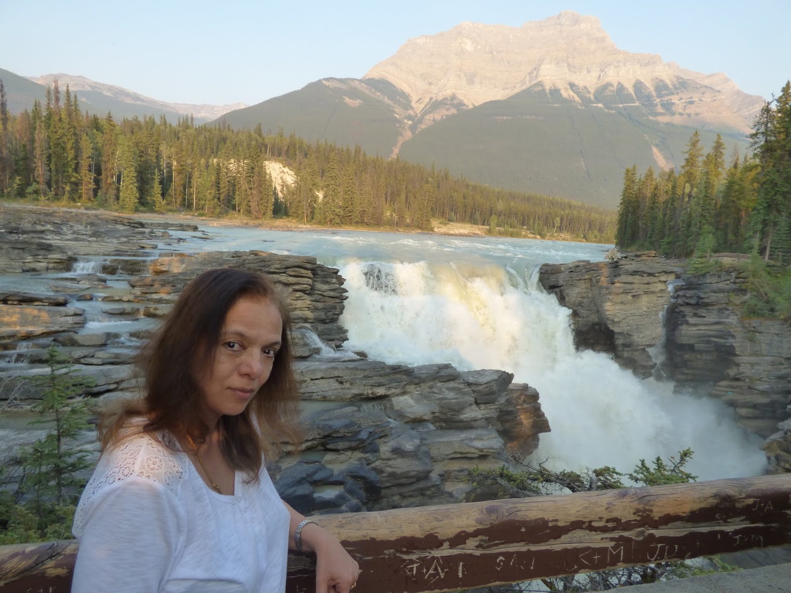
Athabasca Falls:
We passed through a nice lodge

Next was the Athabasca falls.

Next was the Athabasca falls.

This waterfall, dropping over a lip of Gog quartzite and thundering down into a narrow canyon, is among the most powerful and awe-inspiring in the mountain parks. The entire force of the Athabasca River is funnelled through this gorge, and the walls of the canyon have been smoothed and potholed by the rushing waters and the abrasive gravel and sand swirled within the current. This is all the more impressive since quartzite is not a soft rock like limestone, which forms most of the Canadian Rockies’ other canyons;


We had missed the true beauty of the
drive after Parker ridge trail, Saskatchewan and Athabasca glaciers
looked as if they were veiled. There was a haze and a thin
silhoutte of mountains, so we did not even stop at some pullouts.
Otherwise we would not have been able to see these waterfalls that
day. The plan was to include them from Jasper.
JASPER:
We reached our apartment at Jasper; 2 lovely rooms. We opened out the ventilators and let in the cold air to
drive way the musty smell and then it was perfect.


We slept off happy how well the major
part of the day has gone.
Day 6, Aug 30, 2017:
There was haze shrouding Jasper as we
started off for our day. We drove toward Maligne lake. Medicine lake
was on the way.
Medicine lake:
Medicine Lake looks a nice lake in
summer when we went, in fall (autumn) the lake will have disappeared.
Medicine Lake is not a lake at all but an area in which the Maligne River (flowing
from Maligne Lake into the Athabasca River) backs up
in spring and summer and suddenly disappears underground. Much like
a bathtub that is filled too fast for it to drain, it becomes laden
with water (lake) until it can slowly drain as the tap flow (runoff)
is reduced (river). during the 1970s researchers used
a biodegradable dye to determine the underground river's
extent. The dye showed up in many of the lakes and rivers in the area
to the point where it became clear that the underground system was
one of the most extensive in the world. Thought to be spiritual by
the native Indians.


Then we reached Maligne lake,
Maligne lake:


We walked
along the shore and then decided to turn back to hike the Maligne
canyon. People book boats to tour the Spirit island, don't know if it
may have been worth it in that haze.
On the way we met up with a jam of
cars parked along the road and people running in the bushes. We too
got out of our car and saw a bear in the bushes. It moved to thicker
shrubs as people chased it for a picture! Our video did not catch the
bear, but there are hilarious shots of the people chasing it!!
Maligne canyon:
We hiked the 1st 2 bridges
of the Maligne canyon. It was pretty good to see how the river had carved out a canyon


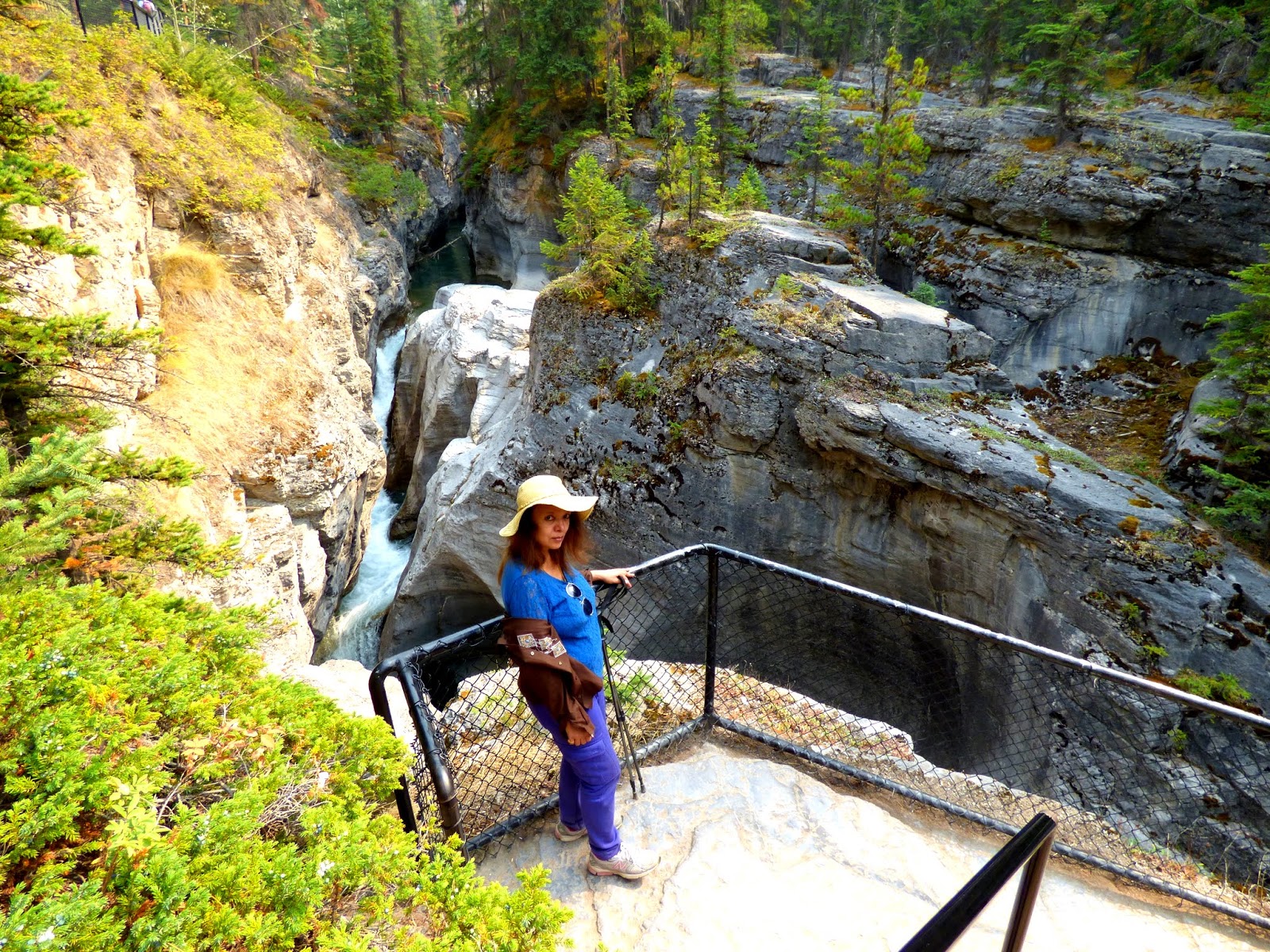

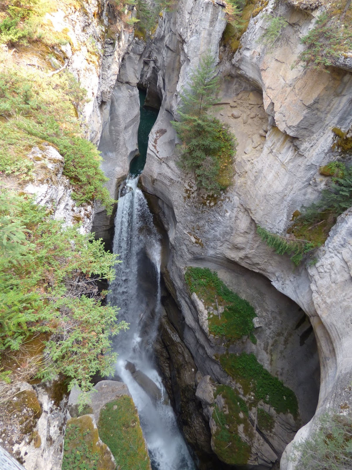

As we drove off, we
stopped at the 5th and 6th bridge too and
enjoyed the sight of the rushing waters of the river.
A belgian missionary had named the river Maligne meaning evil as he had a tough time crossing it on his horse!


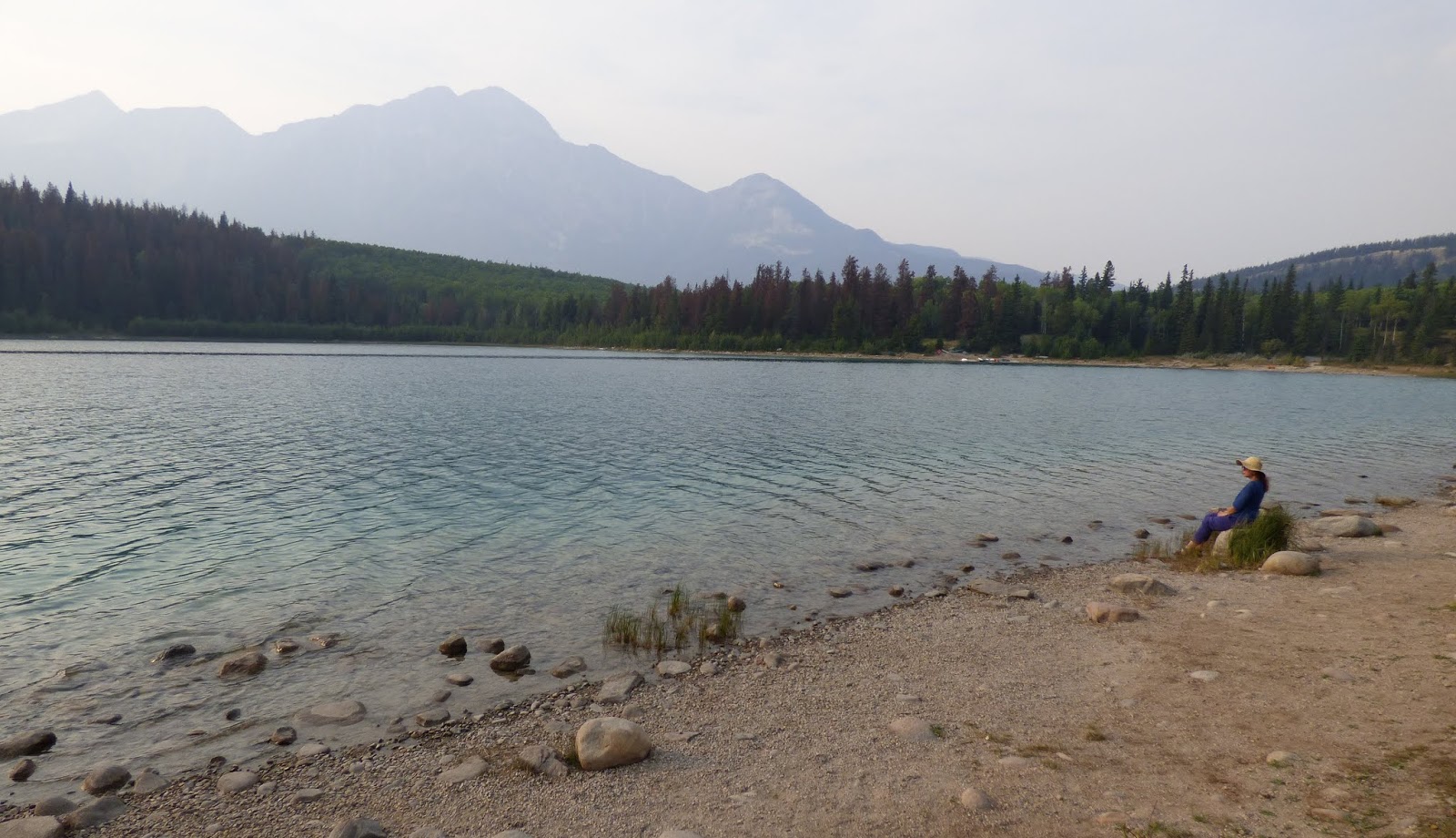
Patricia and Pyramid Lakes, Jasper:
We then visited Patricia and Pyramid lakes.


We were leaving Jasper next day. We
were heading toward Vancouver and were stopping for the night at Lac
le Jeune, which is up a small hill above Kamloops. We had 2 options
of route to reach Kamloops, we may be able to see the salman run and
grizzlies and Mt Robson on the 1st route. The other option
was to drive the Icefields parkway again, north to south and at lake
Louise, go toward Golden and onward to Revelstoke and then Kamloops.
It's always advisable to drive the
Icefield parkway in both directions as we get a different lovely
perspective. Also for us the later part had been in a haze. We
decided we'll let the weather decide and slept off! As luck would
have it, we did drive the Icefield parkway again and had clear
weather!!
Video link:
Icefield Parkway:Banff to Jasper
Next post is at:
http://adventuretrav.blogspot.com/2017/10/canada-trip-report-day-7-jasper-to-lake.html
No comments:
Post a Comment