Japan Trip Report, Apr12-28, 2024, Day 12: Kamikochi, Takayama old town
DAY 12, Apr 23 Tues 2024: Kamikochi, Takayama old town
Kamikōchi (上高地, Upper Highlands)
Kamikōchi is located in the Hida Mountains, the "Northern Alps" of the Japanese Alps. The surrounding mountains reach 3,190 m (10,470 ft). Kamikōchi is bordered on its northern end by Mount Hotaka, and on its southern end by Mount Yake, an active volcano.
It is one of Japan's National Cultural Assets, on the list of Special Natural Monuments and Special Places of Scenic Beauty
Kamikochi is a 15 kilometer long plateau along the Azusa River, about 1500 meters above sea level. It is surrounded by tall mountains, including Nishihotakadake (2909 m), Okuhotakadake (3190 m), Maehotakadake (3090 m) and the volcanically active Yakedake (2455 m).
It is open only during specific dates spring to fall, eg from April 17 until November 15 in 2024 and shuts down during winter.
Take a bus from Takayama to Hirayu Onsen (60 minutes, 1600 yen, hourly), from where there are two buses per hour to Kamikochi (25 minutes, 2800 yen round trip).
Kamikochi valley is protected as part of the Chūbu-Sangaku National Park, road access is only granted to shuttle buses, taxis. Private vehicles not allowed.
Here's a map with relevant stops circled
OUR PLAN
Instead of going all the way to the last stop at Kamikochi we planned to get down at the Taisho ike bus stop and hike 3.2 km along the river to Kappa Bashi, Kamikochi
Saw some pretty sights from the bus.
Pink moss in a garden...
Taisho Pond
The simplest way to enjoy a day in Kamikochi is by hiking the trails along Azusa River from Taisho Pond to Myojin Bridge. It is a mostly flat terrain and requires no hiking experience and only a few hours of time. Two hiking paths along the river from Kappa bridge to reach Myojin bridge. The northern path is longer but winds through a beautiful wetland. The southern path is mostly under the shades of trees and about 1/3 shorter.
We got off the bus at Taisho pond stop as planned. Taisho Pond is an amazing spot in Kamikochi wowing us while entering the park.
The pond is formed by the eruption of Mt. Yake (Yakedake), standing in the background, about hundred years ago.
The trail is top notch with wooden boards to ford streams and marshy areas, there are a lot of signboards as well, explaining the features in the vicinity, so the hike was an amazing experience
The Azusa River, the headwater of Japan's longest river, the Shinano River, flows the length of the valley, filling Lake Taishō at the base of Mt. Yake. Lake Taishō received its name because it was formed by the eruption of Mt. Yake in 1915, which was part of the Taishō period in Japan
BEAR BELL
From April to November 2023 in Japan, there were 193 bear attacks recorded, leading to six fatalities. The Ministry of the Environment presented a report to an expert panel in January 2024, stating there had been 19,192 sightings of Asian black bears in the seven-month period from April through the end of October in 2023. This was the highest number on record, surpassing the 18,000 sightings reported in 2020. Generally, sightings peak in June and then fall until October, which in many years, would be when the number would start rising again. However, this year, sightings have been increasing earlier in September and nearly 6,000 were reported for October alone. The Ministry of the Environment considers this to be the impact of poor beechnut crops, which bears feed on in autumn.
In other parts of the world like US or Canada bear bells are not considered effective to ward off bears but in Japan they think bears will associate the sound of the bell with presence of humans and avoid encounters.
anyway we rang this bell on the trail as they instructed. usually it is better to talk while hiking because bears can recognise human voice. It's good not to be isolated but hike in the company of other people nearby.
WILD LIFE, BEWARE!
Japanese Macaque ( called “nihonzaru” or “Japan monkey” in Japanese) and Black bears live in this area and have been spotted.
2023 had seen phenomenal rise in the spotting of black bears throughout Japan and warnings are in place to alert visitors. we did not carry any bear spray but were a little alert.
we spotted a monkey swinging from branches on the other side of the river. Heard a lot of bird chirping, thankfully there was no other encounter with wildlife
Plank to ford a stream....
TASHIRO POND
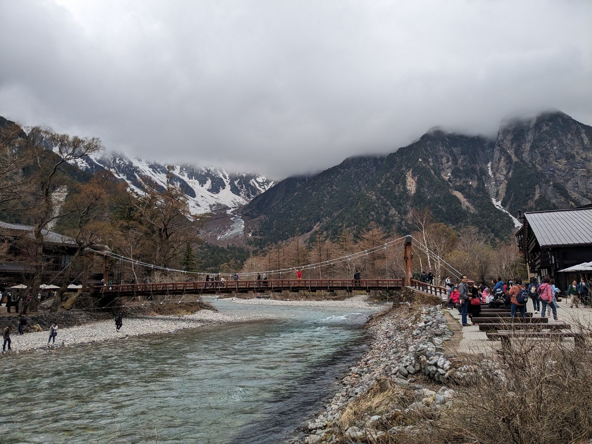
KAPPABASHI
We had hiked 3.2 kilometres and Kappa Bashi was in sight.
Kappa are mythical water deities said to inhabit Japan's mountain streams and rivers. Bashi means bridge
The KAPPA bridge offers a perfect vantage point that frames Mt. Myōjin (2,931 m) and Mt. Oku-Hotaka (3,190 m) between forested valley walls. Beneath Kappa Bridge, river stones and fish are easily visible through the cold, clear current of the Azusa.
The first Kappa Bridge was a drawbridge, but it was rebuilt in 1910.
we had our picnic meal in the scenic surroundings
We could have walked past the
Kappabashi but we decided to take the bus back to Hirayu Onsen. From
there we wanted to take the bus to Shin Hotaka rope way.
HIRAYU ONSEN BUS CENTER
The weather had turned and it was drizzly. In fact even in the morning forecast, the weather was predicted to become rainy in the afternoon.
The bus centre at Hirayu onsen had a nice waiting room with benches displaying lovely carvings.
we asked the staff selling tickets to check and confirm the weather at Shin Hotaka. They confirmed it was raining and foggy out there and will remain so for the rest of the day.
We saw the live webcams and decided to take the bus back to Takayama.
Takayama old town
We did not go to the final stop Nohi bus centre but decided to get down in the old town.
We roamed around for a bit, it has been beautifully preserved with many buildings and whole streets of houses dating back to the feudal ages, the Edo Period (1600-1868) when the city thrived as a wealthy merchant town.
The southern half of the old town, especially the Sannomachi Street, survives in a particularly pretty state with many old homes, shops, cafes and sake breweries, some of which have been in business for centuries.
We tried some hot miso soup given as samples...
Old sake breweries
Sake is one of Takayama's local specialties. Several old sake breweries can be found in Takayama's old town, recognized by sugidama (balls made of cedar branches) hung over their entrances
A 30 minute tour for two on these pedicabs costs around 7000 yen
stone tortoise...
stone frog
Nakabashi red bridge
Nakabashi Bridge is a vermillion bridge that goes across the Miyagawa River, a symbol of Takayama and the gate to the Old Town.
Lovely map...
We walked back to our apartment. Had a chocobar
The next day we had an early checkout at 7:00 AM, we had already bought the tickets to Kanazawa from the Nohi bus centre. We did feel a little disappointed for missing Shin Hotaka but we were more than happy at the beautiful weather we had enjoyed while hiking through the lovely kamikochi area.


.jpg)
.jpg)
.jpg)
.jpg)


No comments:
Post a Comment