DAY 11, Dec 8, 2013, Bariloche:
The
name Bariloche comes from the Mapuche Indians language Mapudungun
word Vuriloche meaning “people from behind the mountain".It is
a beautiful town on the banks of the lovely lake Nahuel Huapi.with mountains Cerro Companario, Cerro Otto, Cerro Catedral towering around.

We
boarded bus 20 from the stop 500 m from our hotel and reached Cerro
Companario.
Cerro Companario:
Our
hotel had given us a bus card the previous evening and we had filled
it with 50 peso credit from a shop on the main road.
We
had also booked 2 tours for the next 2 days—one to Cerro Tronador
and the next—Bosque del arrayanos and Isla Victoria cruise.
In Bariloche, The bus stops are marked in kilometers, from the centre of town to Llao Llao (around 25km in total).
At km 17,8 is the foot of Campanario Hill, the chairlift takes us to the summit 1,050 meters high.
As
can be seen the chairlift at Companario does not have footrest.
People have to lift up the armrest and get out of the moving
chairlift...It was a fun ride up.


From
there we can see beautiful views of the Lakes Nahuel Huapi and
Perito Moreno, Small Lake El Trebol, San Pedro and Llao Llao
peninsulas and Victoria Island.


Nahuel Huapi lake:
Nahuel
Huapi lake, located within the Nahuel Huapi National Park, has a
surface of 529 sq km , is 2,510 feet over the sea level, and
has a maximum depth of 1,437 feet.

It
is 174.8 miles(76 km) long, and at its widest, 27.6 mi (12km) across.
It empties into the Limay river which joins the Neuquén to form the
Negro river which ends at the Atlantic...
The
name of the lake derives from Mapuche language "Island of
the Jaguar (or Puma)",
nahuel,
"puma (or jaguar)", huapí, "island". There
is, however, more to the word "Nahuel" - it signifies "a
man who by sorcery has been transformed to a puma" (or jaguar).
Nahuel
Huapi lake's seven branches are named Blest (36 km²), Huemul (21.5
km²), de la Tristeza (18.5 km²), Campanario (7.9 km²), Machete,
del Rincón and Última Esperanza—Hope, Corner, Machete, Blest,
Sadness,and Narrowness translated...
It
is connected to other smaller lakes such as Gutiérrez, Moreno,
Espejo and Correntoso.
The
deep-blue waters hold a number of islands, most notably Isla Victoria
with 31 km².
The
lake’s crystal clear waters are very susceptible to climate changes
and have an average surface temperature of 45 °F (7 °C), this makes
it both beautiful and treacherous. Hypothermia is one of the risks
bathers must undertake.
Snowy
mountain peaks above forested hills, clear, blue water and enough
vistas to satisfy anyone.


This
cross reminds us of Cristo Redentor of Rio.


Looks
like heart island but heart island is in lake Mascardi which we saw
the next day on our tour to Cerro Tronador.


This
is Lago Perito Moreno.
Here's
another deck for viewing...the
ever present Argentina flag.


 View of the lower deck...


Can
see the houses on the island.
We got down to the entrance after an hour.. several tour buses make this their 1st stop on circuito chico tour.
CIRCUITO CHICO:
On
the road waiting for the bus 20.

Circuito
Chico is a famous scenic route—35 km long one way. people hire
cycles and zip around. We decided to take the bus which covers most
of the route and then get down at its terminal and walk.
Seeing
a group of hikers getting down we also got down at Bahia Lopez.
We
learnt it's 6 km away from the stop. We had our lunch at the stop and
decided to wait for the next bus which was supposed to arrive in 20
minutes. but the bus did not come for 45 min... we decided to walk
back on the route...


Chico
means little ... it should be renamed circuito longo...
The
route is scenic but it was a warm day and tackling the sloping road
became a little tiresome.. we had a jacket and a sweater which had to
be tied to the waist.. applied sunscreen frequently and longed for a
cap.
This
is a weed but very pretty similar to Scot's broom..Cytisus scoparius—flowers
smell good— it is Spanish broom.
Evergreen
fir trees.
After a walk of 3 km, we spotted a bus stop and waited there and caught the bus back to centro. The driver had probably taken things easy on weekend... the bus was packed to capacity. We had spent 3 hours on circuito chico before reaching centro.
In
hindsight, we could have walked to Bahia Lopez and seen the famous
cemetery of mountaineers.
A
better look at the day's high temperature would have come in
useful—we need not have carried layers.
Cerro Otto:
In
centro, here we are on the way to catching bus 51 to go to Cerro
Otto.

Saw several trees wearing lovely sweaters...This is called yarn bombing— a type of graffiti or street art that employs colorful displays of knitted or crocheted yarn or fibre rather than paint or chalk.

This started in Bariloche in 2011, when the town was covered with grey ash from the erupted volcano—-somebody decked the tree barks with colorful creations to brighten the place.
Got only one pic—before we could take a video of the other colorful trees , our bus came.


Here's Cerro Otto—at km 5
http://www.telefericobariloche.com/ingles/ubicacion.htm
The cable car travels from 800 to 1.405 meters above sea level. It covers a distance of 2.100 meters at approximately 3 m/second, transporting 500 passengers per hour.
It has a height of 1405 meters above sea level and is located on the south shore of Lake Nahuel Huapi , near its eastern end.

The hill is named after Otto Goedecke , one of the early pioneers who had his farm on the slopes of the hill. From the top of Cerro Otto a panoramic view can be seen in three hundred and sixty degrees, overlooking the lake Nahuel Huapi , the Moreno Lake , the lake Gutierrez , the Tronador , the Cerro Cathedral, the Cerro Campanario , and the peninsulas of San Pedro and Llao Llao . There is a rotating cafeteria at the top station of the gondola.
When we buy tickets for the cable car, transport from and to the centro is included. But when we went to the office at centro at 4 PM it was closed...so we took our own bus to the foot of the hill and bought the cable car tickets.


We spent a lot of time on this terrace and then went to the art gallery.

ART GALLERY:
Exact copies of art pieces, certified by the Italian government — identical to the original.
Made of 80% marble powder and 20% acrylic resin. .
David :
Story of original David statue:
500 years ago, with nothing more than a chisel and a hammer, Michelangelo sculpted the masterpiece " David" from a block of pure marble, which is in the Academy of Florence.
The original statue is 17 feet high, 6 ton in weight. In 1464, the Operai contracted Agostino to create a sculpture of David. A block of marble was provided, from a quarry in Carrara, a town in the Apuan Alps in northern Tuscany. Agostino only got as far as beginning to shape the legs, feet and the torso, roughing out some drapery and probably gouging a hole between the legs. His association with the project ceased, for reasons unknown, with the death of Donatello in 1466
The block of marble remained neglected for twenty-five years. Though Leonardo da Vinci and others were consulted, it was Michelangelo, only 26 years old, who got the commission. he took 2 years to complete it... It took four days to move the statue the half mile from Michelangelo's workshop into the Piazza della Signoria.


MOSES:

The original Moses is found in Rome, in the church of San Pietro Located in Vincoli.
It
was sculpted by Michaelangelo approximately in 1500 A.D. on a block
of Carrara marble.
PIETA:

In the year 1501 Michaelangelo sculpted the original Pieta (Piedad), from a block of Carrara Marble. The original is in St Peter's basilica, Rome.
A
young serene Mary holding her adult son after
crucification—Michaelangelo made the proportion look good with
voluminous robe for Mary and making the statue pyramidal in shape.
His
answer to people who queried why Mary looks so young? He
said Chaste women don't age.
We
have seen all the originals in Italy, it was good to see these
replicas too.
We
bought fridge magnets at the souvenir shop. Wanted to go to the other
side, but they had already closed it down and hurried everyone out by
6.30... they said winds were making it dangerous to operate the cable
car.
Anyways,
we got a free ride to the centro and then went back to our hotel
taking no 20 bus.
Wished
we could have handled the circuito chico better but the day had
become OK in the latter half!

This lake is glacial and morraine dammed.(glacial debris (soil and rock) have blocked the melted glacial water into a lake—that is called morraine dammed).


Camping site here as there are lots of activities available like rafting/ fishing etc.
 The board says: el bosque es vida—forest is life
 coihue trees.


Trout in plenty in these waters... we could see them in the clear waters

 The Mascardi lake is 23 km long and 4 km wide and 218 m. deep. The Mascardi lake is V shaped with two branches. One arm is aligned north-south direction, branch Catedral and the other oriented east-west, Tronador (according to the proximity of each mountain).

This beautiful sheet of water is 30 kilometers south of Bariloche, on Route 40, has numerous places for picnic and camping. The road to Pampa Linda/ Cerro Tronador passes Los Rápidos, after which it becomes extremely narrow. Traffic is therefore allowed up to Pampa Linda until 2pm. At 4pm cars are allowed to leave Pampa Linda for the return trip. All tour buses stop at this view point—mirador...

 .
.


The mountain was named Tronador (Spanish for Thunderer) by locals in reference to the sound of falling seracs.


There was an hour's stop at the foot of Tronador. This is Our van... gave a comfy ride on gravel roads.


the parking space at the foot of the mountain—- we had requested them to keep the bus open so that we could keep our food bag there before starting on our trek... proved useful.
After the trek at the foot of cerro tronador, we were off to see the black glacier.

It incorporates deposits that give a characteristic dark color, differentiating it from other glaciers , which are usually white/blue like Perito Moreno Glacier in Santa Cruz province. This receding glacier is fed by the constant thundering avalanches and ice crumble from the Río Manso Glacier, 700 m above the mountain.


 It is 1,000 meters high.

 Seracs that have broken off from the glacier floating in the river.


DAY 12, Dec 9, 2013: Cerro Tronador tour:
page
has the map of our trip.
Nahuel Huapi National Park:
We
are at the entrance of Nahuel Huapi National Park, 12 km from
Bariloche.
Paid
the entrance for the national park.

Lago Guttirez:
This lake is glacial and morraine dammed.(glacial debris (soil and rock) have blocked the melted glacial water into a lake—that is called morraine dammed).


Along
the western border of the lake, a trek of 2 km leads to a beautiful
waterfall surrounded by ancient coihue trees...150 ft tall, dia 6
feet.
This
cascade is called cascade of elves. Had
a short stop at the rapids.


Camping site here as there are lots of activities available like rafting/ fishing etc.

impida que— prevent
queme—burning/fire.


Trout in plenty in these waters... we could see them in the clear waters

LAGO MASCARDI:

Near the apex of the two arms lies the Heart Island (Piuque Huapi) seen here.

This beautiful sheet of water is 30 kilometers south of Bariloche, on Route 40, has numerous places for picnic and camping. The road to Pampa Linda/ Cerro Tronador passes Los Rápidos, after which it becomes extremely narrow. Traffic is therefore allowed up to Pampa Linda until 2pm. At 4pm cars are allowed to leave Pampa Linda for the return trip. All tour buses stop at this view point—mirador...
Besides the lake, the tall trees are awesome too...

The
Upper Manso river and the Claro streams and Casalata, flow here.

CERRO TRONADOR:

We
resumed our trip and reached Mount Tronador.
Tronador
is an extinct volcano in the southern Andes, located along the border
between Argentina and Chile near the city of Bariloche.

The mountain was named Tronador (Spanish for Thunderer) by locals in reference to the sound of falling seracs.
With an altitude of 11500feet, 3,470 m, Tronador stands more than 1000 m taller than nearby mountains in the Andean massif, making it a popular mountaineering destination.

Located inside two National Parks, Nahuel Huapi in Argentina and Vicente Pérez Rosales in Chile, Tronador is part of an alpine landscape of fjords, glacial lakes and u-shaped valleys. Tronador has eight glaciers covering its flanks: Alerce, Ventisquero Negro, Casa Pangue, Castaño Overa, Río Blanco, Frías, Peulla and Manso...We saw Manso and Ventisquero Negro.
Tronador is located in the Wet Andes, a zone of high precipitations in form of both snow and rain. The humid temperate climate of the southern Andes allows several glaciers to develop due to high accumulation rates.
The named peaks on Tronador: Anon or Interacional (3484m), Argentino (3187), Chileno (3262), Torre Ilse (2585).
Ridges: Filo Sur (3054), Filo Blanco (3146), Filo La Vieja (2715), Filo Lamotte (2340),

There was an hour's stop at the foot of Tronador. This is Our van... gave a comfy ride on gravel roads.

Had
lunch in picturesque surroundings—with the water falls cascading
down

Garganta del Diablo:

Later
we went up to the origin of the falls up the mountain....a short 600m
trek..


Lovely entrance to the trek...Garganta del Diablo= devil's throat.


Lovely entrance to the trek...Garganta del Diablo= devil's throat.

Waterfalls
in full view.
 A caution sign about the dangerous steps.


As
our guide had warned us not to attempt dangerous treks but to stop at
the stream, we stopped here and sat at the stream enjoying the lovely
scenery for 1/2 hour.
Later
we saw people coming down the steps, so we also went up the route,
TACKLING THE DANGEROUS STEPS hurrying along and reached the end of
the trek.... the foot of the water fall.


 An old gentleman took this pic but did not include the falls...
 They are warning that avalanches occur here...


We don't know if the guide told us to stop here or at the sight of the stream... anyways, it was nice to reach the end of the trail though it would have been better if we had not postponed this last part by sitting around at the stream...
Filled up water from the stream.
Lovely sight to see the birth of a river from the snow.


Came
down the hill by 2 as our guide had told us to...

the parking space at the foot of the mountain—- we had requested them to keep the bus open so that we could keep our food bag there before starting on our trek... proved useful.
Lovely
weather—-usually it rains a lot here.


Ventisquero Negro—The Black Glacier:
After the trek at the foot of cerro tronador, we were off to see the black glacier.
Ventisquero
Negro—The Black Glacier is one of the seven glaciers occupying the
summit of Cerro Tronador in San Carlos de Bariloche , Province of Rio
Negro , Argentina .

It incorporates deposits that give a characteristic dark color, differentiating it from other glaciers , which are usually white/blue like Perito Moreno Glacier in Santa Cruz province. This receding glacier is fed by the constant thundering avalanches and ice crumble from the Río Manso Glacier, 700 m above the mountain.


Saw several small avalanches from the glacier—captured one on video.


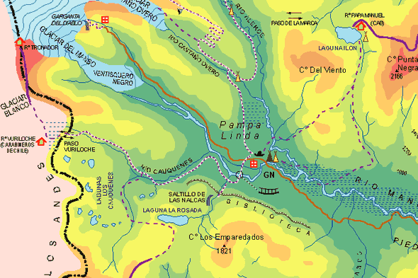
PAMPA LINDA:

Here is the map that shows Garganta del diablo, Ventisquero negro and Pampa Linda, and river Manso.


We
had a snack break at Pampa Linda.
After
the tour we were dropped off at centro... we took bus 20 back to our
hotel as we could not see any interesting places to explore near the
bus stop.
This
tree is on the 500m walk back to our hotel from the bus stop. Wonder
who does such " art".


Went
to the private beach at the back of our room. Owner's dog sniffed our
hand, became friends and escorted us on the path down to the
beach...waited at each junction to see if we were following... then
indicated that we should relax on the lounges...

here
it is taking a dip in the freezing cold water and inviting us to do
the same!!!
Another lovely day was in store...
http://adventuretrav.blogspot.com/2017/06/argentina-trip-report-day-13-bosque.html
Another lovely day was in store...
http://adventuretrav.blogspot.com/2017/06/argentina-trip-report-day-13-bosque.html
No comments:
Post a Comment