PERU TRIP PLANNING:
Peru is truly inc(a)redible and we loved it!! We had 2 weeks during Thanksgiving holidays in Nov 2014 and we had an AWESOME visit to lovely Peru.
Peru is most famous for Machu Picchu but there is a whole spectrum of possibilities for tourists.

We chose our priorities based on time available and logistics. We planned and executed it with no help from agents. We had a hectic trip covering a lot of places in depth in a short span of time. Our scheduling had let us acclimatize to the altitude and we did not experience any sickness. We did not take any medication… did not try the cocoa tea also.
ALTITUDE FACTORS:
The altitude plays a big part as most
of Peru is in high altitude region and one has to be careful not to
fall prey to altitude sickness. 2,500 m (8,000 ft) above sea level is
the elevation at which altitude sickness can occur. The risk of
altitude sickness increases as you go higher. Oxygen level is lower
the higher we go up and this may lead to Soroche (the Spanish word
for altitude sickness). We had to plan our trip with this factor in
mind as we came across tons of reviews where people had become sick
and some had to be hospitalized!
For an idea of the altitudes of some major landmarks, see below:
Highest point
on Inca Trail (Warmiwañusqa pass) 4,200 m (13,780 ft)
Puno (Lake
Titicaca) 3,810 m (12,500 ft)
Chivay
3,630 m (11,910 ft)
Cusco
3,399 m (11,152 ft)
Huarez
3,052 m (10,013 ft)
Urubamba
2,870 m (9,416 ft)
Ollantaytambo
2,792 m (9,160 ft)
Pisac
2,715 m (8,907 ft)
Machu Picchu
2,430 m (7,970 ft)
Arequipa
2,350 m (7,710 ft)
WHAT TO SEE?
Here's a map of attractions...

OUR INCLUSIONS:
Here's a map of what we covered but in the reverse direction to what is specified here...and excepting for the flights in and out of Peru, we traveled by the road. By taxi from Cusco to Ollantaytambo and back, later by public luxury coach Inca Express from Cusco to Puno (for Lake Titicaca), again another coach from Puno to Chivay (Colca Canyon), then onward to Arequipa. So we managed to see all the lovely scenery in between too!

MACHU PICCHU:
The ancient city of Machu Picchu perched
high on a ridge, 300 meters above the Urubamba River is definitely
the highlight for any itinerary.

Trains leave from Cusco, Ollantaytambo,
or Urubamba to Aguas Calientes. From Aguas Calientes,
the town below Machu Picchu, a bus takes visitors up to Machu Picchu,
which is about a 20-minute drive.
SACRED VALLEY:
The beautiful sacred valley, an hour's
drive north of Cusco, comes a close second.. This fertile valley has
many Inca ruins worth exploring and is also a peaceful area to soak
up local culture. The towns of Pisac, Urubamba, and Ollantaytambo
have fabulous ruins; Moray has circular terracing used as an
agricultural testing area by the Incas, and Maras, the salt mines
at Salinas, which have been in use since the time of the
Incas.
Below is the Ollantaytambo fortress ruin...


Below is the Ollantaytambo fortress ruin...


[Incan empire is the largest empire in
pre Columbian days and the period is from 1200 AD to 1572 when the
Spanish brought down their last bastile. In Quechua, Inca means
King,,, so it's technically wrong to use that word as extension for
all things pertaining to that period. However, there is a common
usage of referring to the people/features of that era as Incan. So
with apologies, I continue with that usage!]
CUSCO:
Cusco, UNESCO World Heritage Site, is
of course a must do. Inca ruins have been used in the foundations of
the lovely old Spanish colonial buildings, showcasing the country's
glorious history.


COLCA CANYON(Cañon del Colca):
We also included Colca Canyon (Cañon
del Colca), which is twice as deep as the Grand Canyon, and is the
second deepest after nearby Cotahuasi Canyon. The canyon reaches
a depth of 3,400 meters and is the result of a seismic fault between
two volcanoes. At the base far below is a winding river. Condors are a huge attraction. Chivay was
our base here.


LAKE TITICACA:
At 3,820 meters above sea level, Lake
Titicaca is the highest navigable lake in the world, and is also an
extraordinarily scenic area. Uros Floating Islands (Islas
Flotantes), which sustain small communities of Uros Indians are
famous. These are man-made islands constructed of reeds that have
sustained a traditional way of life since the time of the Incas.
real charm lying in the small villages in the hills along the shores
of Titicaca and on the main islands of Isla Taquile and Isla
Amantani.


The main gateway to Lake Titicaca is the city of Puno. But we wanted a stay in an island and we were so lucky to be the only residents for the whole day on an island Isla Suasi in Lake Titicaca.
AREQUIPA:
Arequipa, at 2,300 meters, is often
regarded as Peru's most beautiful city. Set against a backdrop of
snow-capped mountains, the city center is UNESCO World Heritage Site.
The city's old architecture is constructed of sillar stone, a
volcanic rock that radiates a bright color in the sunlight. Most of
the colonial buildings in the historic city center are made from this
stone, giving rise to its nickname of the "white city."

Most people start their trip here so that they can acclimatize before moving on to high altitude. We however decided to do the best first... scheduling Machu Picchu early. Instead of staying at Cusco which is very high altitude, we chose Ollantaytambo as our base. Urubamba could have been an option but we preferred the small Incan village and had no regrets.

Most people start their trip here so that they can acclimatize before moving on to high altitude. We however decided to do the best first... scheduling Machu Picchu early. Instead of staying at Cusco which is very high altitude, we chose Ollantaytambo as our base. Urubamba could have been an option but we preferred the small Incan village and had no regrets.
OUR MISSES:
INCA TRAIL:
We did not do the 4 day Inca trail as
we can handle only day hikes. A comfortable bed and proper bathroom
are essential for our preferences. There is a sense of regret about
missing this experience though we did have several awesome hikes in
the region.
AMAZON:
Amazon: half hour flight from Cusco,
Puerto Maldonado is a key jumping-off point for tours of the Amazon.
Here's hot humid jungle and a chance to see unique wildlife. Caimans,
capybara, monkeys, parrots, turtles, and piranhas. We decided to skip
this and focus on just the south of Peru for this trip.
HUAREZ:
Huarez was on our wishlist... but
logistics denied its inclusion... matter of huge regret.
BOLIVIA:
Most people cross over to Bolivia from
Lake Titicaca... we did not because we did not want to overschedule.
We had a plan B that we'll move to Arequipa and stay there if we
encountered altitude sickness problems while following our original
plan. Thankfully we were OK. The plan to acclimatize at Ollantaytambo
worked for us.
NAZCA LINES:
Nazca lines were another interesting
feature we chose to miss. Here's a short account of what they
are...these lines stretch as long as 10 kilometers, and they are
spread over hundreds of square kilometers.
The lines were created by
removing the dark surface layer of stones and piling them at the
sides of the lines, creating a contrast between the dark stones and
the exposed lighter soil below.
From the air, it is possible to see
70 different plant and animal drawings as well as hundreds of lines
and other geometrical shapes. Most notable among the figures are a
lizard measuring 180 meters long, a condor with a 130-meter wingspan,
and several others that include a monkey, hummingbird, killer whale,
and spider.
The lines were probably the product of the Paracas and
Nazca cultures between 900 BC and AD 600. They may be a type of
astronomical calendar for agriculture, walkways joining ceremonial
sites, or part of a water cult.
Flights can be booked in advance to
see these but of course weather should cooperate. We could not
schedule it in regretfully.
LIMA:
Of course confining ourselves to the
southern corner ruled out many other areas. Lima may have been good
as well but we just scheduled our flights with no halt in Lima. Some
reports of crime in the city contributed to that just as we had
avoided Buenos Aires on our trip to Argentina. I'm sure everything
would have turned out to be just fine if we had just followed normal
precautions and included them.
WHEN TO GO:
The high season is June to August, but
the two months on either side of this also see decent weather and can
be a good time to visit with fewer crowds. Rainy season is from
November to March.
Overall, the best time to visit Machu
Picchu is from April to October. However we needed to schedule this
holiday end of November which is the beginning of summer/rainy
season. Shoulder season worked for us with hardly any crowds and
great mild weather.
ALTITUDE SICKNESS:
Keeping ourselves well hydrated,
and eating simple easily digestible food worked for us. Drinking some
Coca tea or chewing the local Coca leaves are recommended to
alleviate symptoms of Soroche but we never tried them. CAUTION: if
you are due for drug testing these are to be avoided.
Slow down, avoid alcohol and give your
body time to adjust. I'm in the habit of rushing around, doing chores
, tidying up etc...there comes a sudden feeling as if the tank is
empty and I had to lie down on a couple of occasions for some 10
minutes or so to feel normal. Trick is to breathe deep and walk/ do
things at a slow pace so that the oxygen deprivation does not set in
and make you feel unwell.
LOGISTICS:
ITINERARY:
Nov 27, 2014: Flight from Houston
landing at 11.30pm at Lima.
Nov 28, 2014: 5am flight from Lima to
Cusco, landing at 6.30am. Private prearranged taxi to our base
Ollantaytambo with sight seeing stops at Maras and Moray on the way.
FLIGHTS:
To give a few details…Our ticketing
was through United Airlines. Houston-Lima-Cusco for the flight into Peru and Arequipa-Lima-Houston for the flight out.
DAY 1: Nov 27, 2014:
We flew in from Houston to Lima, landed at 11.30 pm, collected our checkin bag and walked over to the LAN counter. They are open throughout the night and checked us in at once for our 5 am flight to Cusco. We stretched out on the chairs at the boarding gate and dozed off for a short time, then washed up and took the flight at 5am. The airport was quite comfortable once we got through the crowded areas.DAY 2, Nov 28, 2014:
Before boarding we requested a seat change to left side of plane for view of Andes when landing. They gave us these emergency seats... GREAT!

Landed at Cusco at 6.30 am. We had arranged through email for driver Marco to pick us up— Maaf3000@gmail.com
His guy was in the baggage area looking for us... we thought he was some tout but later realized he was OK. We drew 50 soles from the ATM


Met up with Marco who was standing outside with our name plate.


Marco would have been sent by our hotel if we had asked them for airport pickup but we approached him on our own through email as said earlier.
Aeropuerto -Ollantaytambo= 45 $ dolares.
Aeropuerto- Maras-Moray- Ollantaytambo=70$ dolares
was his quote; we happily paid for the latter.
We have basic Spanish, Marco has teeny tiny bit English, we got along great!
We have basic Spanish, Marco has teeny tiny bit English, we got along great!

.We needed a big bottle of drinking water, Marco stopped at a store that opened that early and we sped through scenic roads and interesting old houses.


Reached Moray.


MORAY AGRICULTURAL TERRACES:

Moray is an Inca agricultural experiment station. Its micro climatic conditions and other significant characteristics led to the use of the site as a center for the ancient study of domestication, acclimatization, and hybridization of wild vegetable species that were modified or adapted for human consumption.
Moray is 50 km (31 mi) northwest of
Cuzco on a high plateau at about 3,500 m (11,500 ft) and just west of
the village of Maras. It is a prototype of a greenhouse or
experimental biological station, very advanced for its age; so
that the Andean Man could consume 3000 different potato
varieties, 150 varieties of maize, and many other rich goods.
We bought the Boleto turistico (tourist ticket) at Moray
which served for a host of sites in sacred valley.

The site contains unusual Inca ruins, mostly consisting of several enormous terraced circular depressions, the largest of which is approximately 30 m (98 ft) deep.


As with many other Inca sites, it also
has a sophisticated irrigation system.
Their depth, design, and orientation
with respect to wind and sun creates a temperature difference of as
much as 15 °C (27 °F) between the top and the bottom.
This large temperature difference was
used by the Inca to study the effects of different climatic
conditions on crops.
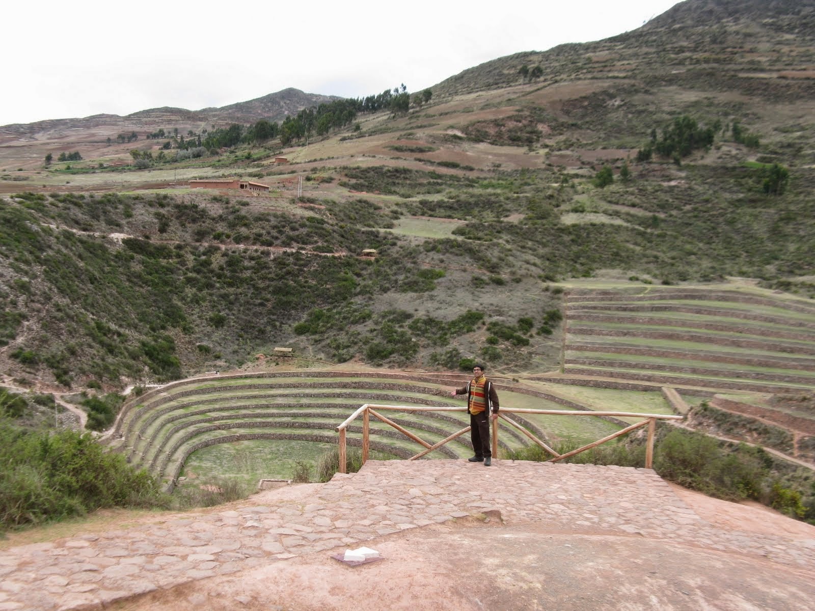


A few early visitors started trickling in.


The agricultural terraces are stunningly beautiful.
There are clean toilets at these
touristy places but many don’t have any TP; We carried toilet
paper, so no worries.


Marco had cautioned us to take things slow, we did so, and hiked to all the vantage points. We had had a long flight, were sleep deprived and the altitude may have added to the difficulty. But it was all so scenic, we felt energized. Except for slight panting, we were OK!
MORAY VILLAGE PLAZA:
After an hour there, we drove on.


here's Moray agri terraces;


here are the Salineras of Maras...


Bought fruits from local ladies at the market—6 tasty bananas for just 1 sole!!


Then we were on our way.
MARAS SALINERAS:
Next was the salineras—another
awesome specimen of the ingenuity of the Incas. They’ve harnessed a
subterranean stream to flow through pans where salt is produced when
the water evaporates.

 Very Scenic place.

Here we are at Maras...as can be seen, 3 CUTE locals were blocking our way... a smile and a cheerful OLA solved the issue!

Matching stride with a local beauty...


Here we are at Maras...as can be seen, 3 CUTE locals were blocking our way... a smile and a cheerful OLA solved the issue!

Matching stride with a local beauty...


Bought some souvenirs from a shop—-very
reasonably priced.


These are Andean good luck symbols...2 bulls with a yoke. These bulls bring good luck, health and prosperity...


These are Andean good luck symbols...2 bulls with a yoke. These bulls bring good luck, health and prosperity...
People place two bulls in the middle of
the roof/highest part of the house. They face in the same direction as the
houses and in between them rises a cross, both a Christian symbol and
something related to Illapa, the thunder god, flags, and metal
roosters.
Here are salt sacks stacked up.


About 3000 small pools with an average
area of 5 m² (53.8 ft²), have been constructed on the slope of the "Qaqawiñay"
mountain.


People fill up or "irrigate"
the pools during the dry season every 3 days, with salty water
emanating from a natural spring located on the top of the complex. Here's the subterranean stream emerging...


We can see the stream running here...between the legs


When water evaporates the salt
contained in it will slowly solidify.
That process will be carried out
approximately during one month until a considerable volume of solid
salt is obtained; about 10 cms. (4 inches) high from the floor.
That solid salt is beaten,
granulated, then packed in plastic sacks and sent to the region's
markets. We had heard this place will look muddy and brown during rainy season and had emailed Marco whether it would be worth visiting in November end... he said YES, and it was GREAT!
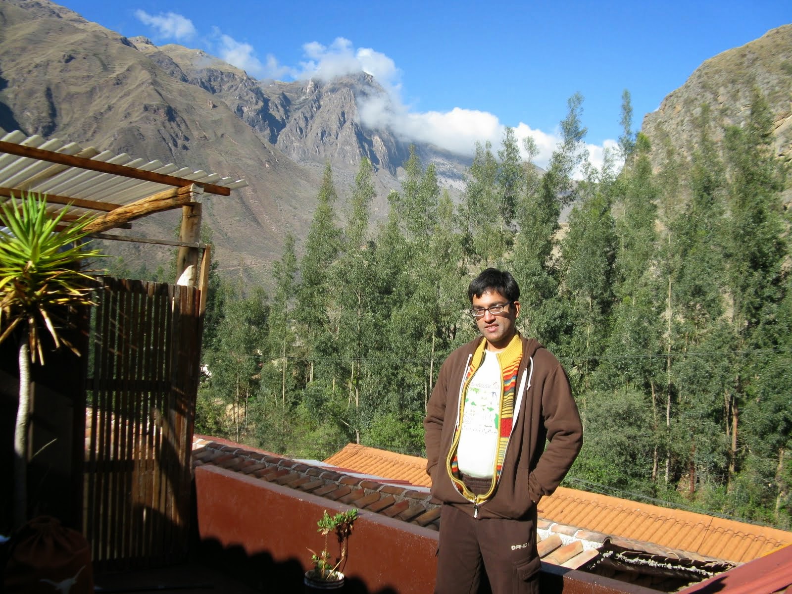
HOSTAL ISKAY, OLLANTAYTAMBO:
Reached our hotel and checked in. Hostal Iskay is in lovely ethnic surroundings at the foot of the mountain (*hostal is inn, name given for hotels with less than
15 rooms).
This room was for 1 night only and we had a bigger nicer room for the next part of our stay when we returned from Machu Picchu.
 This is skylight...
 the private terrace is awesome!


This room was for 1 night only and we had a bigger nicer room for the next part of our stay when we returned from Machu Picchu.


It had been great leaving our bags in
the car with trusty Marco and doing our sight seeing right after
landing. All the sites had no other tourist around as you can see
from our pics—-it was such a soul stirring moment enjoying them in
such solitude!
We had the paratas , tomato relish and cashew sweet we had brought with us and slept off early.
The next post about our Ollantaytambo Ruins hike and train to Aguas Caliente is here:
https://adventuretrav.blogspot.com/2017/06/peru-trip-report-day-3-ollantaytambo.html
We had the paratas , tomato relish and cashew sweet we had brought with us and slept off early.
The next post about our Ollantaytambo Ruins hike and train to Aguas Caliente is here:
https://adventuretrav.blogspot.com/2017/06/peru-trip-report-day-3-ollantaytambo.html
No comments:
Post a Comment